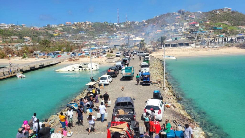
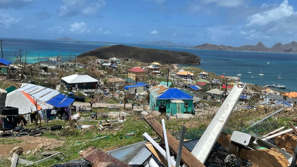
June, too soon; July, stand by; August, come they must; September, remember; October, all over. This is an adage we have heard for many years as it relates to the hurricane season, but this time around, the story was different—at least so early in the hurricane season. ‘
Major Hurricane Beryl devastates the Southern Grenadines’ …’Beryl leaves a trail of destruction in the Eastern Caribbean’ …’Total devastation on Union Island as residents pick up the pieces following Major Hurricane Beryl’
These are just a few of the headlines that one saw across their screens and online in the immediate aftermath of the passage of Hurricane Beryl.
There were very few to none who captured the real reason why this hurricane was able to go from a tropical storm to a Category 3 hurricane in under 48 hours.

What transpired was an incredible force of nature: a major hurricane packing winds over 140 miles per hour bearing down on islands that never expected or experienced such wrath in their lifetime. The result was near-total damage and destruction on three of the Southern Grenadine Islands.
One has to first understand the true gravity of what transpired in the southern Grenadines to be able to make the connection with what was the catalyst for such a monster: warmer Sea Surface Temperatures (SSTs).

Above : Record warm temperatures spread through most of the Tropical Atlantic, of note is how warm Sea Surface Temperatures were as Hurricane Beryl Closed in on St Vincent and the Grenadines on July 1st . (Graphic Source: NOAA)
The picture began to look grim for the Windward Islands on Friday, June 28th. There was an indication that somewhere in the Windward Islands would be impacted by a tropical storm or hurricane, but as the weekend progressed, the outlook changed, and we were now facing a major hurricane in the making with a track taking it somewhere between Tobago to the south and St. Lucia to the north, with St. Vincent and the Grenadines in her crosshairs.
As it would pan out, Beryl tracked directly over the island of Carriacou, with the strongest winds in the northeastern quadrant sweeping across Union Island, Mayreau, and Canouan in the Southern Grenadines. As Beryl lashed the islands with all her might, contact was lost with these islands, and it was only days later that aerial and ground photos and footage began to emerge, showing the scope of the devastation on the islands.
In the days following the disaster, there were chilling first-hand accounts of the experiences of those who rode out the hurricane on those islands. So far, six people are confirmed to have lost their lives on Union Island during the passage of Beryl, with others still missing, including a ferry, the MV Guidance II, which broke anchor and was sent adrift in the rough seas during the hurricane with a captain and crew of five onboard.
Heidi Badnock, a resident of Union Island with a population of just under 3,000, shared her personal experience as to how quickly things went downhill. She recounted the moment she took refuge under a bed after parts of the roof were ripped off and the many hours she remained under that bed as the winds howled on the outside and her home was torn to pieces. She recounted…
Hurricane Beryl brought home the true power of wind…I could hear the wind and feel the building shaking, it felt like an earthquake but that was just the wind.
She compared the experience to that of a visit to the dentist for a wisdom tooth extraction: “It was doing all it could to remove the roof… it was yanking and yanking and yanking until the roof came off…” She added that the sound of the living room chandelier crashing to the floor was an indication that the roof over that area was gone.
After several gruelling hours, Ms. Badnock was able to see what occurred on the outside. What she saw was unlike anything she had ever witnessed. “The entirety of the valley area where I could see—all, all, all—the roofs were gone, every single one of them,” she said. She stated that despite the destruction, those who lost their roofs and homes were still grateful that they survived, and there was a rekindling of the community spirit.

Just eleven miles away on the island of Canouan, with a population of approximately 1,700, Terrance Bynoe spoke of similar scenes of destruction as he filmed what was unfolding outside his window. Galvanised sheeting being ripped off homes and flung great distances. He described the intense scene on the outside: “It was like a tornado. It was just spinning around and this is what took off many of the roofs.”
As he was contemplating his next move, he said, “As I watched a sheet of galvanize that was spinning in the air like a top and I said no no no…I had to move.” Fortunately, there was a brief lull in the winds, which allowed him and his family to seek refuge in a safer space downstairs of the family home. Moments later, he heard his roof lift off on the upper level of his home.
After the hurricane, Bynoe was able to see what happened around him. He said the roads were all impassable and scattered with debris, including downed electric poles and wires. He saw members of the community coming together like those on Union Island to immediately clear the roadways and assist each other in securing property from the elements.
Billy Jeffers, Manager of the SVG Meteorological Services, is of the view that record warm temperatures in the Tropical Atlantic were one of the key players in the rapid intensification of Hurricane Beryl. He noted that it was an anomaly, and the last event of this magnitude was experienced some 126 years ago when the Great Hurricane of 1898 ravaged the islands, leaving a trail of death and destruction.
A total of 12 inches of rain fell during its passage, and over 200 deaths were recorded. Jeffers says the outlook for the remainder of the season shows a worrying trend as record-warm SST combined with other climatological factors make the Atlantic ripe for the formation of storms and stronger hurricanes.
This is supported by the latest forecast from the US-based National Oceanic and Atmospheric Administration’s (NOAA) National Hurricane Center (NHC) which, as of their June 2024 updated forecast, calls for an 85% chance of an above-normal hurricane season with 17–25 named storms, 8–13 hurricanes, and 4–7 major hurricanes.
While there is very little that we can do as people of the Caribbean region to slow down or stop issues such as rising sea surface temperatures, we can continue to speak up on the global stage and use every opportunity and platform available to appeal to the larger countries that contribute greatly to climate change to take corrective measures to avert a global climate crisis down the road. At the moment, all we can do is hope for the best but be prepared for the worst because, as the trends indicate, the worst is yet to come. The time to speak up for global action is now!
—
This story was originally published by NBC SVG, with the support of the Caribbean Climate Justice Journalism Fellowship, which is a joint venture between Climate Tracker and Open Society Foundations.